Streamside Subdivision in Lewiston, Maine
 Project Overview
Taylor Engineering Associates of Auburn, Maine prepared development plans for the Streamside Subdivision in Lewiston for Maine Source Realty, also of Auburn. Streamside is an 84 lot subdivision located on the edge of the developed portion of Lewiston expanding an area of existing 7,500 sf to 10,000 sf house lots. In addition to local approvals, the proposed development required permits under three Maine Department of Environmental Protection laws, Site Location of Development, Natural resource Protection Act and Stormwater. Since 2005, Maine’s Stormwater Law has required developments to treat water quality and, for large projects such as the Streamside Subdivision, water quality. State regulations also required that two previous subdivisions be included in the stormwater design of Streamside increasing the project to 120 lots and 67 acres. The development was approved by the city in 2010.
Existing Conditions
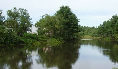
 The project is located at the bottom of a 284± acre watershed and surrounds a
small unnamed pond located just before the runoff discharges to No Name Brook.
The rest of the watershed is a mixture of developed areas, including a large
trailer park, a power line, meadows, woods and wetlands.
The project is located at the bottom of a 284± acre watershed and surrounds a
small unnamed pond located just before the runoff discharges to No Name Brook.
The rest of the watershed is a mixture of developed areas, including a large
trailer park, a power line, meadows, woods and wetlands.
Proposed Conditions
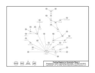
Taylor Engineering Associates has been using HydroCAD modeling software since 1994 and have found it to be very intuitive to use and powerful in modeling complex hydrologic and hydraulic problems. We used HydroCAD on this project to model the entire 284± acre watershed to the outlet of the pond in order to take advantage of hydrograph lag and detention effects of the existing pond. Additionally, Streamside Subdivision was proposed to the City of Lewiston to be developed in four major phases and we were required to show that after each phase was completed the development still met water quality and quantity requirements.
To meet the requirements of the Stormwater Law five wet ponds were proposed, including conversion of a detention basin, constructed for one of the previous developments, into a wet pond. Several buffer areas were also proposed in order to bring treated impervious surfaces up to the required 75% for the over 7,000 lf of roads and 95% for the house lots. After the existing and full build out HydroCAD models were developed, intermediate models were prepared for Phases 1 through 3 to check against the existing condition. Using HydroCAD we were able to size emergency spillways for the wet ponds to time peak discharges so they did not coincide with the hydrograph for the overall watershed. This saved space and construction costs for the owner as wet ponds were sized only to provide water quality treatment.
May 2012