 What is the Curve Number?
Each subcatchment uses a Curve Number (CN) to
characterize the runoff properties for a
particular soil and ground cover. The CN value is a primary input
parameter for the SCS runoff equation, as used by HydroCAD.
High CN values (such as 98 for pavement) cause most of the rainfall to appear
as runoff, with minimal losses. Lower values (such as 58 for certain
wooded areas), correspond to an increased ability of the soil to retain
rainfall, and will produce much less runoff.
 How
is the runoff calculated?
How
is the runoff calculated?
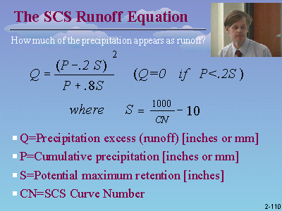
The runoff volume is calculated with the SCS runoff equation, as show at the
right. The equation is simple enough to evaluate by hand, or you can use
an on-line
runoff calculator. Disclaimer: This link is an
independent 3rd party web site. Although we're not aware of any issues
with this site, you assume all risks associated with the use of the site.
Note that the combination of low CN and precipitation values will produce
zero runoff. This is an expected result of the SCS runoff equation. If the term (P-0.2S) is negative, the rainfall is less than
the initial abstraction, and there will be no runoff.
How do I determine the Curve Number?
The curve number is based on the hydrologic soil group and ground cover.
The subcatchment entry screen in HydroCAD includes a "Lookup" button that lets
you browse a table of CN values that is based on the TR-55
reference table.
How do I determine the Hydrologic Soil Group?
The HSG depends on the soil type. For a list of soil types and the
associated HSG, click the "Help" button on the CN lookup table. Also see
the soil information page.
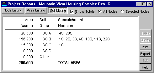
For a breakdown of the soil groups within a given project, see the new
Soil Listing report which was added in
HydroCAD-8.5
Curve number weighting
In general, the most accurate results are obtained when each subcat is
homogeneous, that is, contains as few CN's as possible. When you average
several CN's into one subcat, the results are not necessarily the same as
creating several subcats and adding them together. For example, a single
subcat will have only one peak, while adding multiple subcats can even produce a
multi-peak hydrograph!
 For handling multiple curve numbers, the following options will be found on
the Advanced tab of the Settings|Calculation
screen:
For handling multiple curve numbers, the following options will be found on
the Advanced tab of the Settings|Calculation
screen:
1) By default, HydroCAD uses a single "weighted-CN" for each subcatchment. The
weighted CN is calculated by taking the sum of each CN value multiplied by
its fraction of the total subcatchment area. The sum is (usually) rounded to
the nearest whole number, as described below. The rounded result is used for all calculations
and reports.
2) Starting with HydroCAD-8 an "SBUH weighting"
option is available to calculate separate runoff from the impervious and
pervious portion of each subcatchment. This allows the SCS runoff
equation to be applied independently to the pervious and impervious areas, and
may produce a significantly different result than using a single weighted CN.
Details here. This weighting method is
commonly used with the SBUH runoff procedure.
3) Starting with HydroCAD-10.0
build 8, a "weighted-Q" option is also
available. This procedure performs a separate runoff calculation for each CN value, and then combines the flows (Q) to produce the total runoff for the
entire subcatchment. The end result is the same as using a separate
subcatchment for each CN value. Although this option tends to improve runoff
accuracy, it is not supported by most H&H programs and therefore is not commonly
used.
Why is the composite CN value rounded?
When using a composite CN value, it is common practice to round the result to the nearest whole
number. Although it is possible to adjust the rounding, using a fractional CN value may yield different results than other programs
and make verification more difficult. It also complicates AMC adjustments,
which are defined only
for integer CN values.
Starting with HyroCAD-8, you may elect to use a full-precision CN value,
without any rounding. This option is available on the Advanced tab of the
Settings|Calculation screen.
Can I change the number of digits used for CN rounding?
Starting with HydroCAD-8, you can change the number of significant digits by
customizing the "CN" parameter directly on the Settings|Units screen.
With earlier versions of HydroCAD you will need to create a custom units definition
file. Find the line that
begins with "CN=" and change the maximum value of "100" to "100.0". This
will add an extra decimal place to the rounded CN value.
What about unconnected impervious areas?
Starting with HydroCAD-9 you can use a special procedure for adjusting
the CN value for unconnected impervious areas.
Details here.
When should I use the pre-averaged CN values?
The CN lookup table includes several pre-weighted CN values, such as "1/4 Acre
lots, 30% impervious", which were developed by the SCS and
published in TR-55 Table 2.2. These CN values are a weighted average
between CN=98 (for the impervious portion) and the standard CN value for "Open
space in good condition". (Also see
Appendix A2 of the HydroCAD Reference Manual.)
When using these pre-averaged CN values, make sure the impervious fraction is
comparable to the actual lots being modeled. In some instances this may
include driveways and adjacent roads, while other designs may exclude these
area. Since the impervious portion is subject to considerable variation,
the pre-averaged values should be used only when appropriate to a specific
application. If the impervious portion is significantly different, you
should enter the pervious and impervious CN values separately rather than using a
pre-weighted value.
What CN value should I use for pond and lake surfaces?
 Water surfaces are typically modeled with a CN value of 98 or higher.
HydroCAD-8.5 includes new entries in the CN lookup table that allow water
surfaces to be classified as pervious or impervious, depending on your reporting
requirements. For details, read about impervious
surfaces.
Water surfaces are typically modeled with a CN value of 98 or higher.
HydroCAD-8.5 includes new entries in the CN lookup table that allow water
surfaces to be classified as pervious or impervious, depending on your reporting
requirements. For details, read about impervious
surfaces.
What CN should I use for gravel surfaces?
TR-55 provides CN values for "gravel streets and roads" including the
right-of-way, but it doesn't provide a CN for the gravel surface alone.
However, the TR-55 values appear to be based on 30% gravel with CN=96 and 70%
"open space" in poor condition. So 96 would be a reasonable value
to use
for the roadway surface alone, since it is highly compacted and has minimal absorption
capability.
However, if the gravel surface is not fully compacted or contains significant
voids, a lower CN value may be appropriate. Although there are no standard
CN values for these conditions, a CN value can be estimated based on the
following procedure.
How do I determine the CN value for "special" conditions?
For some conditions, such as a layer of sand over an impervious surface, you
may be able to estimate the CN value by using the SCS equation for the
potential maximum retention, as listed above:
1000
S = ----- - 10 where S is in inches
CN
If we calculate S as the available voids in the sand, we can estimate the CN
value by rearranging the equation as:
1000
CN = ------- where S is in inches
S+10
For example, 10 inches of sand with 30% voids would have a maximum retention
of 3 inches, corresponding to a CN value of 77. This approach may also be useful for
roof gardens or other artificial soil profiles in which
the total voids are known.
What about artificial turf?
Modeling artificial turf requires careful consideration of the exact behavior
of the system.
Modeling runoff from artificial turf requires the determination of an effective CN value,
which is sometimes available from the turf supplier. However, the CN
value you achieve will depend largely on the base material, so it is important
to follow manufacturers recommendations carefully. In some cases, you may
be able to estimate a CN value based on the potential maximum retention, as
described above.
However, most turf installations are designed to intercept the entire
rainfall without producing any surface runoff. This requires rethinking of
the "runoff" calculation, typically using a high CN value (such as 98) to
calculate the flow that will be intercepted by the turf and passed into sub-turf storage.
Details here.
What about porous pavement?
Modeling runoff from porous pavement requires the determination of an effective CN value,
which is sometimes available from the pavement supplier. However, the CN
value you achieve will depend largely on the base material, so it is important
to follow manufacturers recommendations carefully. In some cases, you may
be able to estimate a CN value based on the potential maximum retention, as
described above.
Modeling infiltration through porous pavement is a
different calculation that requires careful consideration. If your goal is
to model sub-pavement storage, and the pavement is expected to capture
(infiltrate) all the rainfall, the "runoff" (infiltrating through the
pavement) could be modeled as a subcatchment with a CN value of 98. For
details read about porous pavement.
How can I tell what curve numbers are used over the entire project?
Starting with HydroCAD-8, you can select the new
"Area Listing" report, which shows a break-down of all curve number usage
throughout the current project. The report is automatically sorted by CN
value, with a separate subtotal for each surface description used in the
project. It also indicates which subcatchments contribute to each entry.
See the sample PDF
report here.
The report is especially useful for verifying that all ground areas has been
accounted for, but not double-counted. It also lets you verify consistent
soil classification between the the pre-existing and proposed analysis.
